
The best hail maps and hail apps for roofers in 2026
The right tool depends on what has to happen after the storm appears: verify it, study the swath, document a claim, or put a route-ready list in a sales rep’s hands.
Disclosure before the comparison: I built RoofHeadsUp. This is not a neutral review, and it should not read like one. The useful standard is whether each product solves the roofing job it claims to solve. A claims team, a multi-state restoration operator, and a five-person sales crew have different bottlenecks.
| Job to be done | Start with | Why |
|---|---|---|
| Verify public hail observations at no cost | NOAA SPC + local NWS | Official public reports; the territory and address work remains manual |
| Navigate radar-estimated storm swaths in the field | HailRecon / Interactive Hail Maps | Interactive maps, historical weather, alerts, and canvassing workflows |
| Combine weather intelligence with claim documentation | HailTrace | Broader severe-weather mapping and multiple report products |
| Hand a small crew a route-ready address workbook | RoofHeadsUp | Hourly monitoring, market filters, street map, and ranked candidate addresses |
What makes a hail map useful to a roofing crew?
Weather accuracy matters, but usefulness is a workflow question. A roofer should evaluate six things: when the data arrives; whether it represents a public observation or a modeled radar swath; how far back the history goes; whether the map works at street level; what property or route information comes with it; and whether the output supports canvassing, claim documentation, or both.
The last question is the one feature grids often miss: what happens after the map opens? If a manager still spends an hour translating a weather layer into a drive list, the map solved the weather question but not the crew-handoff question.
Best free starting point: NOAA and local NWS reports
The NOAA Storm Prediction Center daily reports and local National Weather Service storm products are the honest place to begin. They provide public observations without a software subscription. If you chase a few nearby storms, understand the limitations of point reports, and have time to build the rest of the workflow yourself, they may be enough.
Their limitation is not legitimacy. It is packaging. A public observation does not automatically become a saved service area, threshold-based alert, property list, street concentration summary, or morning route. It also does not prove that a particular roof was damaged.
Best for radar-swath field work: HailRecon
Interactive Hail Maps pairs browser mapping with the HailRecon mobile app. Its public product materials emphasize radar hail swaths, historical maps, replay, alerts, address monitoring, street-level zoom, and field canvassing tools. That makes it a logical fit when a crew wants to study a visual storm path, navigate the map directly, and manage field activity in the same platform.
RoofHeadsUp does not attempt to reproduce that interactive weather-history depth. Our detailed HailRecon versus RoofHeadsUp comparison explains where each workflow is stronger.
Best for deeper weather and claim reports: HailTrace
HailTrace is broader than a hail map. Its public product pages describe severe-weather mapping, notifications, property and canvassing features on some plans, and several levels of weather-history and claim-oriented reports. Meteorologist involvement is central to its positioning. That depth can matter to larger restoration companies and teams supporting insurance documentation.
RoofHeadsUp reports are not insurance evidence and are not represented as meteorologist-certified reports. If that is the job, choose the tool built for it. See the full HailTrace versus RoofHeadsUp breakdown for a more precise comparison.
Best for a route-ready small-crew handoff: RoofHeadsUp
RoofHeadsUp is deliberately narrower. A scheduled hourly scan checks public NOAA/NWS observations against a customer’s selected markets and minimum hail size. When an observation qualifies, the crew gets an alert, a street-level priority map, and a three-tab workbook containing a storm brief, up to 500 ranked candidate addresses, and a street summary.
The product is for the operator who does not want another storm dashboard to interpret. It answers: “Did qualifying hail reach one of our markets, and which nearby streets should we field-check first?” Plans start at $39 per month, and every paid plan includes a focused government roofing bid feed across the six covered states.
It is not a homeowner lead marketplace, a continuous radar-analysis suite, or proof that any candidate property sustained damage. The distinction between intent leads and geographic field candidates is explained in storm damage leads versus hail address reports.
Read the map before acting on it
A point report, a radar-estimated swath, and a distance tier answer different questions. A point records an observation near a location. A swath estimates a storm footprint. A distance tier helps organize nearby addresses. None of those is a roof inspection, and a circle around a report should not be presented as the exact edge of damage.
For example, a crew planning work after hail in Oklahoma might first confirm the event time, then compare street clusters with its service area and travel limits. That is a planning exercise—not a claim that every address in the cluster has a damaged roof.
RoofHeadsUp · published monthly pricing
1 service area
3 service areas
10 service areas
14-day trial. Every paid plan includes hail alerts, ranked address reports, and government roofing bids. Compare plan details.
A practical buying scorecard
- Use NOAA/NWS when the budget is zero and someone on your team can do the territory and address work.
- Use HailRecon when radar-swath navigation, replay, and in-field canvassing are the center of the workflow.
- Use HailTrace when broader severe-weather intelligence, meteorologist review, and claim-oriented reports justify a deeper platform.
- Use RoofHeadsUp when a small or midsize crew wants the storm filtered to its market and handed over as a ranked field list.
These products can coexist. A company might use a deep weather platform for analysis and documentation, then use a route-ready address report for field deployment. Buy against the bottleneck you actually have, not the longest feature list.
How this comparison was produced
The criteria came from the real sequence a roofing operator follows after hail: detect, verify, decide, route, inspect, and document. Competitor descriptions use public product and pricing materials linked below; we did not perform a head-to-head accuracy test. RoofHeadsUp claims were checked against the live product and approved report format. No company paid for placement, and no unverified customer-volume or accuracy claims were used.
Product capabilities and plans change. Recheck official vendor pages before purchasing. A dated correction or material product change can be sent to info@roofheadsup.com.
Frequently asked questions
What is the best hail map for a small roofing company?
For a small crew, the best choice depends on the handoff. Use NOAA or local NWS reports when cost matters and you can do the research yourself; HailRecon when interactive radar-swath field navigation matters; HailTrace when deeper weather analysis or claim-oriented reports matter; and RoofHeadsUp when you want qualifying alerts converted into a ranked address workbook.
Is there a free hail map for roofers?
Yes. NOAA Storm Prediction Center daily reports and local National Weather Service products are free public starting points. They show reported weather, but they do not automatically create a service-area filter, property list, or canvassing route.
Does a hail map prove that a roof was damaged?
No. A public hail report or modeled radar swath is a prioritization signal, not proof of damage at a specific property. A lawful on-site inspection is still required.
What is the difference between a hail map and a hail address report?
A hail map visualizes reported or modeled storm activity. A hail address report turns a storm location into a ranked list of nearby properties and a street concentration summary so a crew can decide where to begin field work.
- September 13, 2026: clarified map interpretation, added workbook proof, current plan pricing, sources, and an on-page sample request.
- August 20, 2026: added quick answer, evaluation method, expanded decision guide, and structured FAQ data.
- August 3, 2026: rechecked product positioning and added Nebraska and Missouri coverage.
- July 18, 2026: first published.
Inside the workbook
From storm context to streets worth checking.
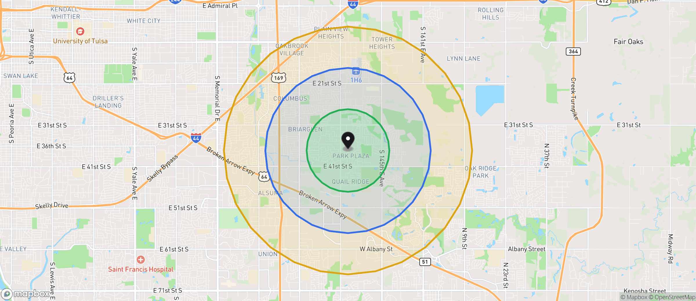
Example workbook map · Oklahoma · distance tiers, not a verified damage boundary.
- 01 / CONTEXT
Storm Brief
Review location, timing, reported hail size, and the map before sending anyone out.
- 02 / PRIORITIZE
Address Candidates
Work through up to 500 ranked candidate addresses. Proximity is a reason to check, not a damage finding.
- 03 / PLAN
Street Summary
Find clusters of candidate addresses, then plan your own field route and verify conditions.